DNR Highlights New ARPA Well Compensation and Abandonment Grant Programs For
"Imagine A Day Without Water"
FOR IMMEDIATE RELEASE: Oct. 20, 2022
Contact: Steve Elmore
[email protected] or 608-259-6100
DNR Highlights New ARPA Well Compensation And Abandonment Grant Programs For Imagine A Day Without Water
Working to ensure everyone has access to safe, clean water is a priority for the DNR. / Photo Credit: iStock/quintanilla
MADISON, Wis. – The Wisconsin Department of Natural Resources (DNR) is joining communities and leaders from across the country and state in taking part in Imagine a Day Without Water, an annual day of education and action to highlight how water is essential, invaluable and in need of investment.
Every day in Wisconsin, 7 billion gallons of water are used, with each Wisconsin resident using an average of 56 gallons. Most Wisconsin residents don’t have to think twice about where that water will come from every day. Still, many other residents lack reliable access to safe water – including some people with access to a private well that has poor water quality. That’s why working to ensure access to safe, clean water for everyone in Wisconsin is a priority for the DNR.
The DNR’s commitment to ensuring safe water for all includes a continued focus on issues related to water infrastructure and water quality. Ongoing work includes enforcing drinking water standards, replacing lead service lines, and addressing contaminants such as PFAS and nitrates.
With $10 million in funding from the American Rescue Plan Act (ARPA), the DNR has expanded the eligibility requirements for the Well Compensation and Well Abandonment Grant Programs. These programs provide financial assistance to owners of private or non-community public wells to address contamination in their wells by awarding grants for the replacement, reconstruction, treatment or abandonment of their well.
With the expansion of the eligibility requirements for these programs, many more
Wisconsin residents with contamination in their wells will be able to apply and gain access to a reliable source of safe water. In the first week after applications opened on Oct. 3, nine applications were already submitted, and applications will continue to be accepted until all $10 million in funding has run out.
Learn more about the ARPA Well Grant Programs on the Well Compensation Grant Program webpage and the Well Abandonment Grant Program webpage.
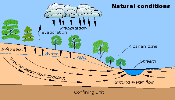
Protecting Your Groundwater
Testing for PFAs
Information received from Vilas County Health.
For additional information, click on the Private Well Testing button.
- Testing private wells for PFAS is very expensive. Starts at around $350 and goes up from there.
- At the moment there are no state or federal funds to help people with the cost of testing.
- There is research currently ongoing looking at private wells in Wisconsin. The samples were collected this summer. Not sure when the results will be coming out. But something to look forward to.
For additional information, click on the Private Well Testing button.
Welcome
In keeping with the priorities of our 5-Year Work Plan, the Oneida County Land and Water Conservation office is currently developing this "Groundwater" page to help educate landowners about proper well monitoring, support efforts to increase private well water teting and assess and share results of collected well water data. This page is still in the preliminary phase. Please be patient with us as we find the most current resources to share with you. As we build this page, we welcome your comments. Contact us at [email protected] if we can help you further.
We are pleased to announce several improvements to assist staff and customers to search for Well Construction Reports (WCRs).
Below is a summary of the tools and features, and a link you can use to try the new search tool. We hope you enjoy these new tools.
We are pleased to announce several improvements to assist staff and customers to search for Well Construction Reports (WCRs).
Below is a summary of the tools and features, and a link you can use to try the new search tool. We hope you enjoy these new tools.
Search Well Records
We have a new interface for anyone to search for well construction reports (WCRs):
https://dnr.wi.gov/WellConstructionSearch/#!/PublicSearch/Index
New features (compared to the old version):
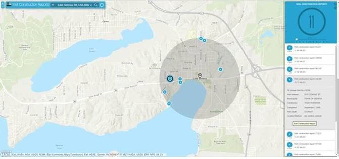
Here is a new map tool that will allow anyone to use a powerful address/place name search tool to zoom to a location. The tool will then find all well construction reports within a radius.
Advanced search options for staff and drillers
Using a different portal, DG staff and drillers will be able to log in to the Well Construction system with a WAMS ID and password. DG staff and drillers can search by geology and other options that used to be available on the Well CD. This will include pre- & post-1988 well construction reports. Full locational information will be available for Municipal wells and OTMs, with a built-in “sensitive information” agreement. This tool provides an option to generate a single PDF that includes well construction reports for multiple wells.
We have a new interface for anyone to search for well construction reports (WCRs):
https://dnr.wi.gov/WellConstructionSearch/#!/PublicSearch/Index
New features (compared to the old version):
- One database to search instead of two
- TN’s and NN’s are now included
- Municipal and OTM’s are also included, with locational information redacted (well address, latitude/longitude, quarter section and quarter-quarter section all hidden)
- Pre-1988 well construction reports are included (available in early January). Multi-page reports have been combined into a single PDF.
Here is a new map tool that will allow anyone to use a powerful address/place name search tool to zoom to a location. The tool will then find all well construction reports within a radius.
Advanced search options for staff and drillers
Using a different portal, DG staff and drillers will be able to log in to the Well Construction system with a WAMS ID and password. DG staff and drillers can search by geology and other options that used to be available on the Well CD. This will include pre- & post-1988 well construction reports. Full locational information will be available for Municipal wells and OTMs, with a built-in “sensitive information” agreement. This tool provides an option to generate a single PDF that includes well construction reports for multiple wells.
|
|
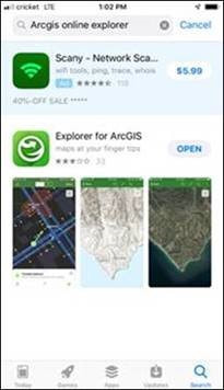
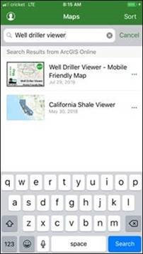
Access Well Driller Viewer using ArcGIS Explorer Mobile app
The Well Driller Viewer map can now be used on a mobile device with ArcGIS Explorer Mobile app. Just download ArcGIS’s Explorer app, then search for the map called “Well Driller Viewer – Mobile Friendly Map”.
Other efforts in progress/future
The Well Driller Viewer map can now be used on a mobile device with ArcGIS Explorer Mobile app. Just download ArcGIS’s Explorer app, then search for the map called “Well Driller Viewer – Mobile Friendly Map”.
Other efforts in progress/future
- Improved well locations – WCR locations are being tied to parcels wherever possible. Individual counties of improved well locations are regularly being loaded.
- Variances – NR 812 variances are being digitized so they can be archived and retrieved, providing additional information about a well to staff and customers.