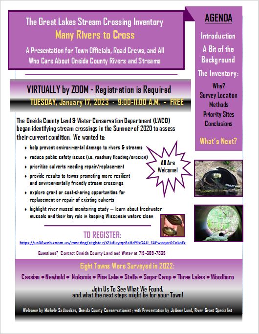
Third and Final Stream Crossing Workshop
|
Watch the third and final Stream Crossing Workshop - Many Rivers to Cross
Video aired January 17, 2023 Click on the button below to view the CHAT BOX questions from the workshop. To just view the presentation only, please download the file to the left "presentation 2022 final.pdf"
| ||
Oneida County Stream Crossing Project Summary
In 2020, Oneida County Land & Water Conservation staff began a project to examine and assess roadway stream crossings in Oneida County. Primary goals focused on preventing/minimizing environmental damage, protecting public safety, prioritizing culverts in need of repair or replacement and sharing this information with infrastructure managers. Surveys continued in 2021 and were completed in 2022, covering the majority of roadway stream crossings on public roadways in all 20 Towns in Oneida County. A summary of completed surveys is shown in the table below.
Completed Surveys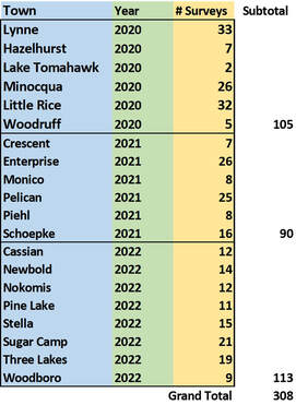
|
The ideal crossing permits water and debris to move downstream unimpeded, does not obstruct fish and other aquatic life from moving up and downstream according to their needs, and allows water to flow downstream after major rainfalls.
Important parameters to include when designing a culvert crossing:
|
Of the 308 crossings, 77% posed at least a partial barrier to fish passage, with 18.3% creating a complete barrier. A portion of structures (15.8%) did not create a barrier to aquatic organisms. Condition of the structure is a common issue, with 34.4% showing major to severe deterioration. Erosion can have multiple deleterious effects on waterways, especially after heavy rain events: 9.4% of crossings were evaluated with erosion levels near or exceeding two tons per year. In addition, 76.2% of culverts were assessed as undersized relative to the waterway they were serving.
It is important to remember that the effects of all culverts in a watershed are cumulative. Data from on-the-ground surveys coupled with improved communication between conservation and infrastructure managers is essential to making positive landscape-based changes that minimize environmental impact.
For additional information see below:
https://www.uwsp.edu/cnr-ap/UWEXLakes/Documents/ecology/shoreland/background/fish friendly_culverts.pdf
All completed survey data may be viewed at the Michigan DNR HUB site
https://great-lakes-stream-crossing-inventory-michigan.hub.arcgis.com
(scroll to bottom of page, access surveys using the Stream Crossing Viewer or the Stream Crossing Dashboard) AND
Oneida County Interactive Land and Water Mapping app
https://www.co.oneida.wi.us/departments/li/land-records-system/
River Mussel Monitoring Update
In 2021 and 2022, Oneida County LWCD staff conducted river mussel monitoring surveys. Mussels provide an important ecological service: they are efficient filter feeders, removing particulate and chemical pollutants from our waterways. Declines in freshwater mussel populations have been documented for decades, making them some of “Wisconsin’s most imperiled animals”. Restoring native freshwater mussels to rivers and streams is of growing interest as a potential strategy for improving water quality and aquatic ecosystem health. All results were entered into the Wisconsin Mussel Monitoring database through the iNaturalist website: https://www.inaturalist.org/projects/wisconsin-mussel-monitoring-program.
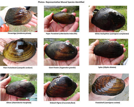
We found 13 species overall at nine locations in Oneida County in 2022. The greatest variety of verified species were from two locations: Nine Mile Creek in the Town of Three Lakes (n=9), and the Wisconsin River in the Town of Crescent (n=6). Two species of particular interest were included. The Elktoe Mussel (Alasmidonta marginata), a “Species of Special Concern” in Wisconsin, was identified from the Wisconsin River location. The Eastern Pondmussel (Ligumia nasuta) is a “Species of Greatest Conservation Need” in Michigan’s Wildlife Action Plan 2015-2025, and was identified during surveys at Nine Mile Creek. This mussel was first documented in Wisconsin in 2014.
For more information on mussel monitoring activities and results see our final reports from 2021 and 2022.
Sample Mussel Photos
2022 - Individual Town Reports
|
| ||||||||||||||||
2021 - Individual Town Reports
|
|
| ||||||||||||
2020 - Individual Town Reports
|
|
| ||||||||||||
Presentations
Click on the files below to view the Presentations
|
Aired on March 25, 2021
| ||
|
Aired on January 25, 2022
| ||
|
Aired on January 17, 2023
| ||