Oneida County AIS Programs
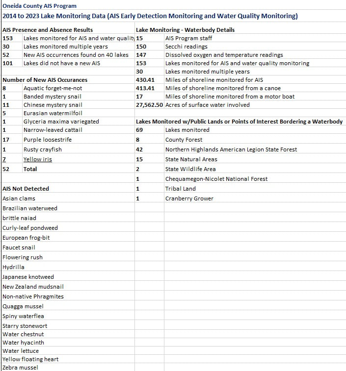
2014 - 2023 Lake Monitoring Results
2014 - 2023 Lake Monitoring Results
Objective
Each summer, the Oneida County AIS Program staff conducts lake monitoring on a minimum of 15 lakes. Our lake monitoring strategy consist of AIS early detection monitoring and water quality monitoring. Early detection of AIS is crucial for effective, inexpensive rapid response efforts and to prevent their spread. Water quality data is evaluated for long term trends and assist with identifying changes and potential problems in the water or watershed.
We work closely with a network of DNR Lakes Biologists, partners (i.e. UW Extension Lakes), and volunteers (i.e. Citizen Lake Monitoring Network). Our efforts help to detect new AIS populations of NR40 prohibited species, enable AIS response efforts, understand the spread of AIS within a lake, understand the health of the waterbody and watershed, and evaluate the relationship between water quality and invasive species.
This monitoring strategy may trigger statewide, regional, or local implementation of a rapid response strategy, lead to an assessment of abundance and frequency within a waterbody and/or an evaluation of management activities.
Lake monitoring contributes to assessments and may address local lake management issues including AIS management, post AIS removal restoration projects, blue green algae blooms, water quality, and other issues.
Lake Selection
Lake selection is based on the DNR’s AIS Prevention Priorities and Strategies and targets vulnerable waterbodies: lakes with little or no data, have not recently been surveyed, proximity-within 15 miles of a known prohibited AIS, busy boat landings with no CBCW efforts, and AIS suitability. Additional factors that prompts lake monitoring includes: suspected new AIS, concerns with the water quality, requests from individuals, lake groups or the DNR, and various special projects.
Data Collection
Data is captured on the Oneida County Land & Water Mapping Application and entered into the DNR's Surface Water Integrated Monitoring System (SWIMS). Click here to download the
Methods: AIS Early Detection Monitoring
Visual Meander Search: Paddle the canoe slowly around the entire lake’s littoral zone looking for AIS, mussels, and snails in the water and along the shoreline. Meander between shallow water and maximum rooting depth or 100’ from shore whichever comes first. To monitor during the meander survey in low visibility, samples will be collected using a plant rake and D-net during the meander survey.
Targeted Search Sites: AIS sampling will be done at a minimum of 5 target sites during the shoreline meander survey and at boat landings (public and commercial). These sites will be sampled using the following methods and tools:
Methods: Water Clarity and Quality Monitoring
Secchi disk, water temperature, and dissolved oxygen meter are sampled at the lakes deep hole. This data provides a snapshot of the lakes health such as the physical, chemical, and biological characteristics of the water.
Visual Meander Search: Paddle the canoe slowly around the entire lake’s littoral zone looking for AIS, mussels, and snails in the water and along the shoreline. Meander between shallow water and maximum rooting depth or 100’ from shore whichever comes first. To monitor during the meander survey in low visibility, samples will be collected using a plant rake and D-net during the meander survey.
Targeted Search Sites: AIS sampling will be done at a minimum of 5 target sites during the shoreline meander survey and at boat landings (public and commercial). These sites will be sampled using the following methods and tools:
- Use aqua view scopes and underwater camera while walking along the shoreline, search vegetated areas; use a D-net to sift through sediment, use a plant rake and analyzing plant rake samples, snorkel for a minimum of 10 minutes to examine underwater solid surfaces, veliger tows and spiny waterflea tows.
Methods: Water Clarity and Quality Monitoring
Secchi disk, water temperature, and dissolved oxygen meter are sampled at the lakes deep hole. This data provides a snapshot of the lakes health such as the physical, chemical, and biological characteristics of the water.